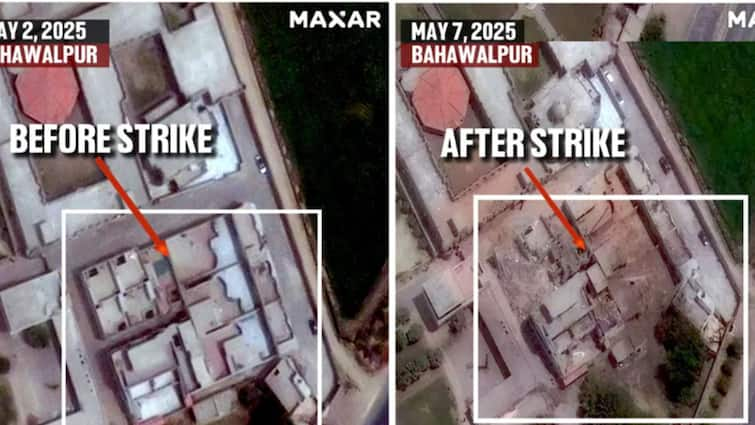
Satellite pictures of the recent major military action taken by India ‘Operation Sindoor’ have come out. These pictures clearly show that many terrorist hideouts in Pakistan and Pakistan-official Kashmir (POK) have been completely destroyed. In this operation, India took major and accurate action against terrorism, which is now confirmed by the issued pictures of the international satellite image company ‘Maxar Technologies’.
What is visible in pictures?
The condition of two major locations Marakaj Subhan Allah (Bahawalpur) and Marakaj Taiba (Muridke) is clearly visible in these high-government photographs taken from the satellite. Earlier, big buildings, training centers and logistic facility were present in these places, now there is only broken roofs, pits and debris.
According to experts, the attacks were so accurate that only targeted buildings were destroyed, the common population or structure was not damaged. This shows that the Indian Army took very thoughtful action.
What were the targets on the target?
- 1. Marakaj Subhan Allah (Bahawalpur)-This was the main hideout of Jaish-e-Mohammed (JEM). It was from here that terrorist attacks were planned. The hand of this center was also told behind the Pulwama attack.
- 2. Marakaz Taiba (Muridke)-This was a big training camp of Lashkar-e-Taiba (Let). Here people like 2008 Mumbai attack terrorist Ajmal Kasab were trained.
- Apart from this, many more locations like Muzaffarabad, Kotli, Rawalkot, Neelam Valley were also attacked.
Why the operation took place?
On April 22, there was a major terrorist attack in Pahalgam in Jammu and Kashmir, killing 25 people. India held the terrorist organizations sitting in Pakistan responsible for this attack. In response, this operation was started.
How did the operation take place?
- In this action, India used air launch cruise missiles, drones (which collide with the target and used long distance cannons.
- Nine places were attacked simultaneously
- Four attacks were carried directly inside Pakistan and the rest in Pakistan-occupied Kashmir
- During this time, Pakistan’s army was not damaged, due to which this action was considered ‘non-respective’ i.e. non-invasive.
What was the effect?
According to defense sources, more than 70 terrorists were killed and more than 60 injured in the operation. Many big terrorist commanders were also killed in this action. The network of terrorist organizations has been badly shaken by the attack. His communication lines and training camps have been ruined.
‘Operation Sindoor’ was a bold and accurate answer to India, which hurt terrorism to its roots. Satellite photos are now testifying that it was not just a claim, but an accurate and successful action.
How satellite image is taken
Satellite images are taken when the satellite (satellite) revolving around the earth takes pictures of the ground with the help of special cameras and sensors. These cameras are very high-government, which can clearly show the buildings, roads, forests, or any change on the surface of the earth. As soon as the satellite passes over a particular place, it takes pictures there and sends them to the station on the earth, where they are analyzed.

